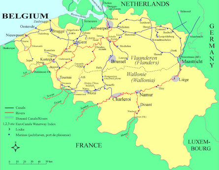
A planning guide for all 52 canals and navigable rivers in Belgium, both in Flanders and Wallonie. Includes an overall map of the country showing the network of waterways and the 10 portals connecting into France and the Netherlands on through-routes.
Maps and dimensional tables for all waterways. Descriptions of interesting towns and cities. Emphasis on the popular cruising areas of Bruges and Ghent, as well as many less traveled waterways.
To download this eGuide now, click on the Buy Now button below.You will be taken to the online payment processor PayPal. You can pay with a credit card or your PayPal account. You do not need to sign up for a PayPal account; just click on "Pay with a debit or credit card", then select your home country.
IMPORTANT: After completing the payment, please WAIT (up to 60 seconds) to be automatically redirected to the "Download" page for your selected eGuide. DO NOT use your Back button. For downloading instructions and answers to questions go to FAQ-Downloading Guides.
EuroCanals Guide: Waterways of Belgium 14.5 Mb, 177 pages US$28.50
Please Note: You are buying the Download (digital PDF) version; also available as a Printed Book
Please Note: the EuroCanals Guides are cruising guides, not navigational charts. They are intended to be used for planning a cruise: they show where you can go and why you might want to go there, with data tables of distances and restrictive dimensions along each waterway. The guides can be used to calculate daily travel estimates. Sources for printed and digital waterway navigation charts are included in the guides.